THE SIBERIAN BRANCH OF THE RUSSIAN ACADEMY OF SCIENCES
THE IRKUTSK SCIENTIFIC CENTER
![]()

V.B. SOCHAVA INSTITUTE OF GEOGRAPHY SB RAS
1 Ulan-Batorskaya St., Irkutsk, 664033, Russia
Теl. (395–2) 42–69–20, Fax (395–2) 42–27–17
e-mail: postman@irigs.irk.ru, www.irigs.irk.ru
Acting director - Igor N. Vladimirov, Candidate of Geography
The Institute was established on 29 November 1957.
The Directors:
1957-1959 – Academician I.P. Gerasimov (Director & Organizer);
1959-1976 – Academician V.B. Sochava;
1976-2000 – Academician V.V. Vorobyev;
2000-2005 – Corresponding Member
V.A. Snytko;
2005-2009 – Corresponding Member A.N. Antipov;
2009-2015
– Doctor of Geography V.M. Plyusnin.
Major research areas of the Institute:
- the state and development of natural geosystems and their components,
- the geographical framework for sustainable development of Siberia’s regions.
The prime mission of the Institute is to pursue basic research in the field of landscape science, the creation of the theoretical foundations for forecasting, monitoring and management of the geosystem dynamics, systemic mapping, the development of the geographical framework for territorial organization of production, and population formation on the territory of Siberia.
Geographical research relies on the state-of-science methodological framework, the theory of geosystems that was created in the Institute. The Institute is proud of its renowned scientific schools on thematic cartography, landscape planning, exo-genous geomorphology, and landscape hydrology.
The Institute has obtained impressive research results on the organization and functioning of natural and natural-technological geosystems as a basis for forecasting the development of the geographical environment, and rational nature management.
A significant achievement of the Institute is comprehensive mapping of nature, the economy and population in various regions of Asian Russia and neighboring countries. The Institute produced a series of very significant cartographic products: the National Atlas of Mongolia, the Atlases of Lake Hovsgol, Transbaikalia, and KATEK, and a variety of thematic maps. A unique cartographic product, having no parallel for the territory of Russia: the Atlas “Irkutsk Region: Ecological Conditions of Development”, and its electron version were published. To date the Atlas has no equal as regards fundamental coverage and content, the breadth of thematic scope, the volume of scientific information, and the quality and standards of representation. Work is currently underway on the development of the theory, principles and methods of cartographic modeling, on the improvement of the information capacity, and real-time computer-aided mapping with the use of aerospace data. Cartographic support is provided to a variety of scientific programs and projects with an emphasis on the Baikal region.
Highly positive results were achieved from a study of the geographical factors of population formation, and of human ecology issues. This area is represented by the individual research blocks: socio-demographic, ethnocultural, medico-geographical, and historical-geographical.
A substantial body of research developments pertain to problems in economic geography and nature management geography in the country's eastern regions. They include general issues relating to nature-society interactions, distribution of productive forces, pioneer development of new areas, agrogeography, georesource science, economic regionalization and the study of basic administrative districts, and to political geography.
Within the scope of Russian-German cooperation, the Russian Federation’s unique methodology of landscape planning as a basis for sustainable development of the territory was developed.
The versatility of the landscape planning tools is attested to by the results from implementing them by territorial planning efforts with a focus on regional and municipal entities in the Baikal region, in the Kaliningrad region, and in the South Caucasus countries: Armenia, Georgia, and Azerbaijan, by water-protection zoning, land utilization, urban development planning, and by zoning of specially protected natural territories. Work has started on project documents for Gorny Altai, and for a number of other territories.
The Institute is engaged in the ecological accompaniment of large-scale projects, among them the projects of development of oil and gas fields, and the creation of transport arteries. Its research results are instrumental in assessing the degree of impact on the ecosystems of natural complexes, their resistance to anthropogenic loads, as well as in making recommendations, based on statistical, evolutionary-dynamical and cartographic data, for a minimization of impacts on ecosystems. Impressive results were also obtained in other branches of geographical science: landscape geochemistry, soil geography, biogeography, geomorphology, hydrology, glaciology, and climatology.
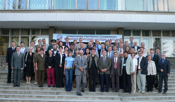
Participants of the International Scientific Conference "World Natural Heritage in Russia"